P0420 Code on Fleet Vehicles: Diagnosis, Costs & Impact
TL;DR 4 key takeaways Definition: The P0420 code indicates that the catalyst on bank 1 of a vehicle is operating below the efficiency threshold,...

August 31, 2019
Author: Daniel Lewis, Senior Data Scientist, R&D Specialist and Inshaal Badar
Hurricane Dorian is expected to be one of the most powerful hurricanes to hit Florida’s east coast since 1992. Every county in Florida is currently in a state of emergency as the Category 4 storm is expected to make landfall bringing with it strong winds and over a foot of rain.
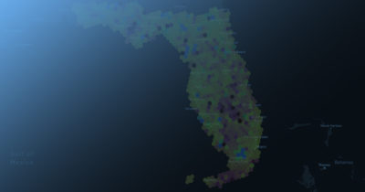
In October 2018, Hurricane Michael hit the Florida Panhandle causing catastrophic damage from wind and storm surge. Three days prior, we were able to see at a macro scale how commercial fleets were preparing for the storm. The areas in red in the images below indicate regions where majority of vehicles had over 50% of their tank filled with fuel while shades of blue indicate regions where the majority of vehicles had less than that.
This time, three days in advance of Dorian, Florida is seven percent more prepared for Dorian than they were for Michael (based on the percentage of commercial vehicles with over 50% in their fuel tank). 95% of regions have more than 50% of vehicles with at least half a tank of gas in comparison to the 88% for Michael in 2018. However, there are still a few areas such as Panama City that seem less prepared than they were last year but most of the cities along the eastern coast of Florida are better prepared this time.
August 30, 2019 (four days before the anticipated arrival of Dorian)

October 6, 2018 (four days before the anticipated arrival of Michael)

While fuel levels are not a complete indicator for preparedness, one never knows the true impact of a hurricane until it touches ground and we urge all of our commercial fleet customers to ensure their vehicles have sufficient fuel to safely weather the storm.
Over the next few days, we’ll be refreshing these maps on an hourly basis to show the impact of the storm on both commercial fleet activity (traffic volumes) and ground-truth weather. Leveraging data from vehicle windshield wiper activation at aggregate, Geotab is able to trace the movement of the storm from the ground and watch as it hits the mainland. We urge those fleets who must be out in the storm to exercise caution during these severe weather events.
Time-lapse ground-truth probability of precipitation over the last 24 hours

Time-lapse commercial traffic over the last 24 hours

For those customers of Geotab, consider applying the rule shown in the animated video below so that you can notify anyone in your organization if any vehicle in your fleets fuel level falls below 50 percent
AttriX is an advanced telematics company that contributes every day to improving drivers’ habits across North America. Thanks to its popular Driver Challenge solution and its Canadian-compliant integrated fleet management solutions, AttriX is positioned at the top of the list to meet the complex needs of Canadian carriers.

TL;DR 4 key takeaways Definition: The P0420 code indicates that the catalyst on bank 1 of a vehicle is operating below the efficiency threshold,...
TL;DR 4 key takeaways Definition: The P0455 indicates a large leak in the EVAP system, detected by the onboard OBD2. Fleet impact: Moderate in the...
.jpg)
AI agent platforms, the co-pilot model, and why technology should serve your people GOOGLE CLOUD NEXT 2026 RECAP , FLEET INTELLIGENCE SERIES PART 3...